Al-Shaykh Muwannis (Arab: الشيخ مونّس), juga Sheikh Munis, adalah sebuah desa Arab Palestina kecil di Subdistrik Jaffa, Mandat Palestina, yang berjarak sekitar 8.5 kilometer dari pusat kota Jaffa di wilayah yang ditandai untuk negara Yahudi di bawah Rencana Partisi PBB. Desa tersebut ditinggalkan pada Maret 1948 karena ancaman dari militia Yahudi, dua bulan sebelum Perang Arab-Israel 1948. Saat ini, Universitas Tel Aviv berada di bagian dari lahan desa tersebut.
Al-Shaykh Muwannis الشيخ مونّس Sheikh Muwannis | |
|---|---|
Bekas rumah dari sheikh desa tersebut, alias "rumah hijau", sekarang bagian dari Universitas Tel Aviv | |
| Etimologi: "The Sheikh Muwannis" | |
Al-Shaykh Muwannis | |
| Koordinat: 32°06′50″N 34°48′15″E / 32.11389°N 34.80417°EKoordinat: 32°06′50″N 34°48′15″E / 32.11389°N 34.80417°E | |
| Grid Palestina | 131/168 |
| Entitas geopolitik | Mandat Palestina |
| Subdistrik | Jaffa |
| Tanggal pengosongan | 30 Maret 1948 |
| Luas | |
| • Total | 15,972 dunams (15,972 km2 or 6,167 sq mi) |
| Populasi (1945) | |
| • Total | 1.930 |
| Sebab pengosongan | Serangan militer oleh pasukan Yishuv |
| Sebab sekunder | Khawatir akan ditangkap dalam pertikaian |
| Wilayah saat ini | Tel Aviv |
Referensi sunting
- Palmer, 1881, p. 218
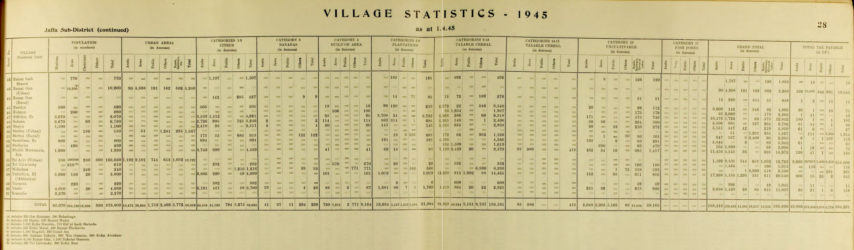
- Government of Palestine, Department of Statistics. Village Statistics, April, 1945. Quoted in Hadawi, 1970, p. 53
- Government of Palestine, Department of Statistics, 1945, p. 28
- Morris, 2004, p. xviii, village #200. Also gives causes of depopulation.
- ^ Daniel Monterescu and Dan Rabinowitz (2007). Mixed Towns, Trapped Communities: Historical Narratives, Spatial Dynamics, Gender Relations and Cultural Encounters in Palestinian-Israeli Towns. Ashgate Publishing, Ltd. hlm. 298. ISBN 0-7546-4732-3.
- Benny Morris (Autumn 1991). "Response to Finkelstein and Masalha". Journal of Palestine Studies. 21 (1): 98–114. doi:10.1525/jps.1991.21.1.00p00682.
Daftar pustaka sunting
- Barron, J.B., ed. (1923). Palestine: Report and General Abstracts of the Census of 1922. Government of Palestine.
- Conder, C.R.; Kitchener, H.H. (1882). The Survey of Western Palestine: Memoirs of the Topography, Orography, Hydrography, and Archaeology. 2. London: Committee of the Palestine Exploration Fund.
- Government of Palestine, Department of Statistics (1945). Village Statistics, April, 1945.
- Guérin, V. (1875). Description Géographique Historique et Archéologique de la Palestine (dalam bahasa French). 2: Samarie, pt. 2. Paris: L'Imprimerie Nationale.
- Hadawi, S. (1970). . Palestine Liberation Organization Research Center. Diarsipkan dari versi asli tanggal 2018-12-08. Diakses tanggal 2009-02-01.
- Karmon, Y. (1960). (PDF). Israel Exploration Journal. 10 (3,4): 155–173; 244–253. Diarsipkan dari versi asli (PDF) tanggal 2019-12-22. Diakses tanggal 2020-07-16.
- Khalidi, W. (1992). All That Remains: The Palestinian Villages Occupied and Depopulated by Israel in 1948. Washington D.C.: Institute for Palestine Studies. ISBN 0-88728-224-5. ISBN 0-88728-224-5.
- Mills, E., ed. (1932). Census of Palestine 1931. Population of Villages, Towns and Administrative Areas. Jerusalem: Government of Palestine.
- Morris, B. (2004). The Birth of the Palestinian Refugee Problem Revisited. Cambridge University Press. ISBN 0-521-00967-7.
- Palmer, E.H. (1881). The Survey of Western Palestine: Arabic and English Name Lists Collected During the Survey by Lieutenants Conder and Kitchener, R. E. Transliterated and Explained by E.H. Palmer. Committee of the Palestine Exploration Fund.
- Pappe, I. (1999). The Israel/Palestine Question. Routledge. ISBN 0-415-16947-X.
- Sand, S. (2012). The Invention of the Land of Israel: From Holy Land to Homeland. Verso Books. ISBN 978-1-84467-946-1.
- Sufian, Sandra Marlene; LeVine, M. (2007). Reapproaching borders: new perspectives on the study of Israel-Palestine. Rowman & Littlefield. ISBN 0-7425-4639-X.
Pranala luar sunting
- Welcome to al-Shaykh-Muwannis,
- Survey of Western Palestine, Map 13: IAA, Wikimedia commons
- Shaykh Muwannis, from Zochrot
- , Zoroch
- , 2003, Zochrot
- 2003.